
Latest News
- Court Sentences Bank Employee To 5 Years For Embezzling 100,000...
- Fake ‘Sheikh’ Sentenced To 2-yr As Court Overturns Verdict
- Justice Ministry New Service On The Sahel App
- Ministry Probes 68 Cases Of Illegal Charity, Funds Collection
- Globally, Kuwait Is Among The Top Consumers Of Incense And Oud O...
- Decrease Seen In Foreign Investment
- Kuwait Customs Seized 2 Containers Laden With Tobacco At Shuwaik...
- Unpaid Salaries, Accountant Beaten Up By Workers
- The Sahel App Was Not Hacked, A Spokesman Claims
- Four Expats Arrested For Stealing Copper Cables Worth 60,000 Din...
- Indian National Died In Abdalli Car Accident
- Work Permits And Foreign Worker Transfers Are Amended By PAM
India Launches Own Gps Satellite
A regional navigation satellite system with just seven spacecraft and in civil domain is unique to India.
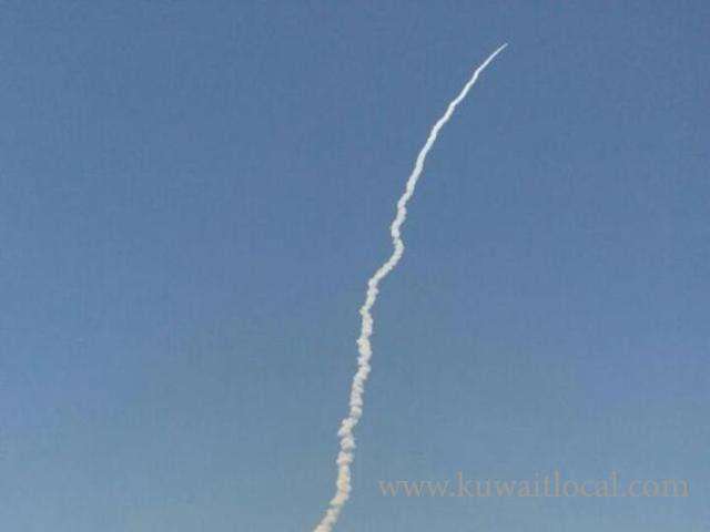
ISRO's PSLV-C33, carrying India's seventh navigation satellite IRNSS-1G, blasted off from the Satish Dhawan Space Centre in Sriharikota at 12.50 p.m.on Thursday. The satellite was successfully placed in sub-Geosynchronous Transfer Orbit.
The countdown for the launch of the 1,425-kg satellite began at 9.20 a.m. on Tuesday. The integration of the rocket on the launch pad and the propellant filling operations were taken up at different stages during the 51.30-hour countdown.
A regional navigation satellite system with just seven spacecraft and in civil domain is unique to India. The three global versions of other countries offer worldwide commercial coverage and are operated by their militaries.
IRNSS (Indian Regional Navigation Satellite System) will be to the subcontinent what the GPS is to its users worldwide, but with far greater precision and in Indian control, according to the Indian Space Research Organisation. It is expected to provide position accuracy of better than 20 m over Indian region and also an area extending up to 1,500 sq. km around India.
The well-known GPS is owned by the U.S. Air Force; Russia has GLONASS and China is expanding its regional BeiDou into a global system, also operated by its military. Europe’s GALILEO is a civil global system. They each have between 28 and 35 satellites.
IRNSS will drive both everyday uses as a 24/7 standard service for air, sea, ship transport among others. It will also be used for military and missile-related applications as an encrypted and restricted service.
Over the next three to six months, all the IRNSS satellites would be stabilised as a constellation, their signals and performance verified and later put to use, an ISRO official said.
Two spare satellites are kept ready to be flown in an emergency. A full-fledged ground control centre in Bengaluru and tracking stations across the country have been put in place.
The constellation has been in the making since July 2013, when IRNSS-1A, was launched. ISRO placedIRNSS-1E and IRNSS-1F in January and March this year, each with a designed life of 12 years.
They are identical, with each carrying a navigation payload and a ranging payload in different bands, according to ISRO.
SOURCE : THEHINDU

Related News

-
 Globally, Kuwait Is Among The Top Consumers Of Incense And O...
18 April 2024
Globally, Kuwait Is Among The Top Consumers Of Incense And O...
18 April 2024 -
 Work Permits And Foreign Worker Transfers Are Amended By PAM
18 April 2024
Work Permits And Foreign Worker Transfers Are Amended By PAM
18 April 2024 -
 In Just Two Years, The Civil Service Bureau Sees A Surge Of...
18 April 2024
In Just Two Years, The Civil Service Bureau Sees A Surge Of...
18 April 2024 -
 Kuwait's Commitment To Combat Human Trafficking
18 April 2024
Kuwait's Commitment To Combat Human Trafficking
18 April 2024 -
 Kuwait's Announces Modernizing Renewable Energy Update
18 April 2024
Kuwait's Announces Modernizing Renewable Energy Update
18 April 2024 -
 Kuwait Society Of Engineers And Indian Embassy Address Engin...
18 April 2024
Kuwait Society Of Engineers And Indian Embassy Address Engin...
18 April 2024 -
 Traffic Light Labeling For Packaged Foods Unveil By Kuwait
17 April 2024
Traffic Light Labeling For Packaged Foods Unveil By Kuwait
17 April 2024 -
 Nazaha Unveils 49 Forged Certificates In 5 Years
17 April 2024
Nazaha Unveils 49 Forged Certificates In 5 Years
17 April 2024
Trending News
-
 Eid Al Fitr 2024: Crescent Moon Not Sighted In Sau...
08 April 2024
Eid Al Fitr 2024: Crescent Moon Not Sighted In Sau...
08 April 2024 -
 Kuwait Implements Home Biometrics Services Ahead O...
14 April 2024
Kuwait Implements Home Biometrics Services Ahead O...
14 April 2024 -
 When Will Eid Al Fitr 2024 Take Place In Qatar, Ba...
08 April 2024
When Will Eid Al Fitr 2024 Take Place In Qatar, Ba...
08 April 2024 -
 On Sunday, The Meteorological Department Warns Of...
07 April 2024
On Sunday, The Meteorological Department Warns Of...
07 April 2024 -
 Kuwait Airways Provides Update On Flight Schedule...
14 April 2024
Kuwait Airways Provides Update On Flight Schedule...
14 April 2024 -
 Kuwait Airways Introduces Convenient Home Luggage...
15 April 2024
Kuwait Airways Introduces Convenient Home Luggage...
15 April 2024 -
 Gathering For Eid Al-Fitr Prayers: Kuwaiti Citizen...
10 April 2024
Gathering For Eid Al-Fitr Prayers: Kuwaiti Citizen...
10 April 2024 -
 Winners Of Kuwait National Assembly 2024 Elections
06 April 2024
Winners Of Kuwait National Assembly 2024 Elections
06 April 2024 -
 Bay Zero Water Park Kuwait: Summer Season Opens Ei...
11 April 2024
Bay Zero Water Park Kuwait: Summer Season Opens Ei...
11 April 2024 -
 An Egyptian Expat Dies At Kuwait's Airport
11 April 2024
An Egyptian Expat Dies At Kuwait's Airport
11 April 2024
Comments Post Comment